This Fuerteventura forum uses cookies
This Fuerteventura forum makes use of cookies to store your login information if you are registered, and your last visit if you are not. Cookies are small text documents stored on your computer; the cookies set by this Fuerteventura forum can only be used on this website and pose no security risk. Cookies on this Fuerteventura forum also track the specific topics you have read and when you last read them. Please confirm whether you accept or reject these cookies being set.

A cookie will be stored in your browser regardless of choice to prevent you being asked this question again. You will be able to change your cookie settings at any time using the link in the footer.
Hi guest and welcome to the Fuerteventura forum.

Thread Rating:
  • 0 Vote(s) - 0 Average
  • 1
  • 2
  • 3
  • 4
  • 5

[-]
Tags
islands canary 2022 volcanic activity

Volcanic activity in Canary Islands 2022
As reported by Canal 4 Tenerife.

Translated


SEISMIC MOVEMENT


NOTICEABLE AND DEEP QUAKE, REGISTERED BY IGN
ONE HOUR AGO UNDER NORTH TENERIFE ISLAND

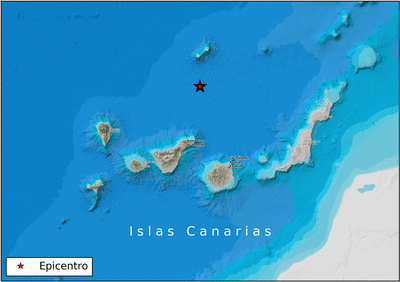
Just over an hour ago a remarkable (magnitude 3.6) and deep (42 kilometers) Earthquake occurred in northern Tenerife. The Earthquake has been registered by the National Geographic Institute (IGN). These are the exact and concise data of that quake.
is2022nvrbx 16/07/2020

19:26:01 GMT time 20:26:01 local time

Coordinates N 29.5128 / W -15.9681
Depth 42.0 km.
Magnitude 3.6 mbLg
ATLANTIC - CANARY BEARIES

The graphs shown are as it was picked up by the stations in Gran Canaria.

1 user says Thank You to jand for this post

1 user says Thank You to jand for this post
The M3.6 was actually North of Tenerife.


2 users say Thank You to jand for this post
The gases seem to be increasing Tenerife and the temperature.

2 users say Thank You to jand for this post
https://www.involcan.org/wp-content/uplo...-en-co.pdf
2 users say Thank You to jand for this post
Translated

18/07/2020 - 23:30h Canary Islands. - THE MATERIALS OF THE COLLAPSE OF THE PALM VOLCANO PYROCLAST CONE AND REGIONAL EFFORTS THROUGHOUT THE ARCHIPELAGO. - Some things do not cease to amaze me and one of them is the pile of materials that was formed by the collapses of the pyroclast cone collapse we had during the eruption, with huge pieces or also called "erratic blocks" that only I had seen in Timanfaya and what happened specifically on September 24-25-26, and another more a few days later to the few days of started the eruption in a way that has remained a tongue of materials almost 1 km long with 20-30m high and 150-200m wide in just a few hours l getting up by in front of everything he caught. I leave you note 461 where you can see a huge erratic block of pyroclasts being washed away by lava.

EDITED: What I'm referring to as Cracked Mountain in the graphic is not.. that's Cogote mountain, I was wrong with the hustle and time spent. And where I put "remains of an earlier hill" is Cracked Mountain. Thanks for letting me know. I've put the corrected drawing below in the replies. (enrique)

https://www.facebook.com/VolcanesyCienci...5KEAzV1ful

From the end of the Road to where they let go up south of the cone, it's stunning to see how a new loma covers the view of the valley that was previously seen and with a few chunks or blocks that will certainly be for the new generations ap make it not laundry only but collapse can be a danger in case of eruption. A heritage that certainly deserves to be preserved and not dismantled for its importance when evaluating volcanic risks. In the foreground there are some very hot laundry from the last days of the eruption, namely laundry 18 of November 25 and 26, which went out under the door of a house and also followed a pre-existing volcanic tube and went further along the photovoltaic central and of course in the cemetery area and below. This laundry is not interesting, its thickness of 1m being very liquid lava almost, which can be dismantled, but remembering the volcanic tube it talked about back in the day.

REGIONAL EFFORTS.

And as the regional efforts continue with small movements in the area of the Caldera de Ucanca in Tenerife and other areas of the surrounding area that indicate that they are following the efforts. This makes you think that if efforts continue, we'll have a new swarm in a few days. The last two have been during the final phase of the moon crescent of the last months of June and July of 2022, we will see what happens now to early August, whether it stops or otherwise it continues with a third swarm, I am hoping and that I do not h there is... I leave you some regional earthquakes, although the location of them leaves much to be desired and the signal of the Earthquake of 3.6 in the seismograms and spectrograms.

es2022nyuad 18/07/2020 12:18:55 27.9675 -15.8398 2.0 km M 2.0 mbLg SW THE VILLAGE OF SAN NICHOLAS. IGC
es2022nvrbx 16/07/2020 19:26:01 29.5128 -15.9681 41.7 km M 3.6 mbLg ATLANTIC-Canary Islands
es2022nwazl 17/07/2020 00:26:18 29.3248 -15.9349 0.0 km M 2.3 mbLg ATLANTIC-Canary Islands

Everyone, politicians, technicians and all people have to be aware that all the dangers we had, a new one joins, the collapses of the cone, which are not ballads above all in size and shape, and that this volcano has shown us that ocu lie. I encourage all the Canary Islands, especially the Palmeros that they are still going through. (enrique)
1 user says Thank You to jand for this post

Translated.

22/07/2020 - 23:30h Canary Islands. - REGIONAL EFFORTS THROUGHOUT THE ARCHIPELAGO AND AN Earthquake CHANGING POSITION HUNDREDS OF KILOMETERS. - Follow the regional efforts (efforts to squeeze the tectonic plate on which the Canary Archipelago is located) and the truth is that it is noticed in unusual earthquakes around the archipelago, including one in the Vol area can of Enmedio and several North of Tenerife, crossing right now all those efforts in the area of the Arafo volcano and the Caldera de Ucanca.

To be honest there are two types of regional efforts: N-S efforts that affect the archipelago by the very movement of the African Plate north and its clash with Europe and other efforts in the E-W direction, possibly originating in The Atlantic dorsal. Between the two they slowly move the archipelago toward the NE, something already known to everyone a few centimeters a year.

Local efforts, due to pressure on magma bodies, are focused on the eruption zone of Palma, in the middle volcano and in Tenerife, specifically in 3 sites: in the Caldera de Ucanca, in Vilaflor de Chasna and in Adeje mainly. Then there are more but less concrete for other areas in the dorsals and more responsive to regional efforts. The volcano in the middle also and surroundings, but even in El Hierro there was one just in the center of the island or around Gran Canaria.

is2022nyuad 18/07/2020 12:18:55 27.9675 -15.8398 1.6 km I-II M 2.0 mbLg SW THE VILLAGE OF SAN NICOLAS. IGC
es2022nzmaf 18/07/2020 21:24:33 27.7172 -18.0077 30.7 km M 2.2 mbLg NW THE IRON PINE. H E I E
es2022ogkue 22/07/2020 16:43:10 28.0327 -16.1914 9.2 km M 2.8 mbLg ATLANTIC-Canary Islands - Enmedio Volcano Zone

THE TRAVELING Earthquake: In the EMSC there are these two options, first one comes out and then the other, the reason for so much difference, no one explains it and leave the most GAP... weird weird. The GAP of these two possibilities is 162 and 310, however they have chosen the farthest, but superficial one to a deeper one that would square the activity we have had during the eruption.

https://www.emsc.eu/Earthquake/earthquak...id=1151636

INITIATIVE

es2022ognea 22/07/2020 17:55:13.23 28.5988 -17.9596 37.1 km M 3.1 mbLg SW TAZACORTE ILP - Azimut 143 GAP 162
https://www.emsc.eu/Earthquake/alert/?id...2022-07-22

REVISED1:
es2022ognea 22/07/2020 17:54:54.79 27.6937 -19.1578 0.0 km M 3.4 mbLg ATLANTIC-Canary Islands - Azimut 174, GAP 310.

https://www.emsc.eu/Earthquake/alert/?id...2022-07-22

Lastly emphasize that in the Palma there are strange noises in the seismogram and follow anthropic sounds at regular intervals of early morning today that are surely a machine or geotechnical, with pulses at very constant intervals of 1 minute.
Another thing you see in the TBT Palma seismogram are the helicopters and planes passing by the Caldera area giving buzz and vibrations at high frequencies, and of course not the noise of the works (including new roads) with time river of construction work from 07:00h to 09:30h... Stop for lunch more work from 10:00 to las13:00h .. Food stop and more noise because of work from 14:00h to 17:00h. with a little more noise until 18:00h.
(Enrique)
1 user says Thank You to jand for this post

2 users say Thank You to jand for this post
The regional efforts chart, oddly the latest Earthquake, squares both sides, though it shifts too much for my liking. The center of the efforts is over the area of Fasnia-Arafo (Enrique)


2 users say Thank You to jand for this post


Possibly Related Threads...
Thread Author Replies Views Last Post
  Canary Islands set for spectacular night sky display with four meteor showers Johnrgby 0 2,893 21-06-2025, 09:39 AM
Last Post: Johnrgby
  Majorero olive oil is once again the best in the Canary Islands TamaraEnLaPlaya 1 4,032 23-02-2024, 07:38 PM
Last Post: TamaraEnLaPlaya
  Volcanic activity in Canary Islands 2023 TamaraEnLaPlaya 80 34,137 20-12-2023, 07:30 PM
Last Post: TamaraEnLaPlaya
  The ban on limpets and burgados begins in the Canary Islands TamaraEnLaPlaya 0 3,147 01-12-2023, 08:48 PM
Last Post: TamaraEnLaPlaya
  Fuerteventura wants to be the breadbasket of the Canary Islands again TamaraEnLaPlaya 1 3,106 14-09-2023, 10:33 PM
Last Post: IHX

Forum Jump: