This Fuerteventura forum uses cookies
This Fuerteventura forum makes use of cookies to store your login information if you are registered, and your last visit if you are not. Cookies are small text documents stored on your computer; the cookies set by this Fuerteventura forum can only be used on this website and pose no security risk. Cookies on this Fuerteventura forum also track the specific topics you have read and when you last read them. Please confirm whether you accept or reject these cookies being set.

A cookie will be stored in your browser regardless of choice to prevent you being asked this question again. You will be able to change your cookie settings at any time using the link in the footer.
Hi guest and welcome to the Fuerteventura forum.

Thread Rating:
  • 1 Vote(s) - 5 Average
  • 1
  • 2
  • 3
  • 4
  • 5

[-]
Tags
islands canary volcanic activity earthquake

Volcanic activity in Canary Islands 2019
Latest update courtesy of Enrique.

"the seismicity continues in Tenerife and surroundings, Canary Islands, Spain.- the seismicity continues to affect the center of the island of Tenerife, and is not the only site, with several activity centers indicated. In el hierro it also moves and with quite a few Events located in the last 15 days. From La Palma, it's shameful, you see earthquakes in the seismogram and more things, but as if they were not, they do not locate them in the ign or for a remedy and above the landslides are still in the caldera of taburiente... something happens, that It's clear.

In Tenerife follow the move, from the area of the south dorsal under vilaflor, with several Events between 6 AND 9 km deep. Then there are many efforts in the high area of fasnia and the eruption of 7 sources, as well as 2 Earthquakes North (in the middle of the orotava valley in the area of the eruption of 1430 and east of this position 120º in the coastal area in front of the volcancito of güímar, which align according to the south sides of the landslides of la orotava and güímar, which seem to indicate local efforts in that low-magnitude area. There are also several earthquakes that are concentrated in one of the branches of the dorsal in the area area of paid in nw-SW direction and aligned with the other swarm in the south dorsal under vilaflor, another area that seems to be reactivated.

Finally, in the sea area between Tenerife and the volcano in the middle there are several Events, both next to this cone between the islands islands, and more towards Tenerife in front of the coast of fasnia and güímar.

In el hierro we say goodbye with a last Earthquake yesterday 3 November of magnitude 2.2 to 27 km deep in the south dorsal, and that could have felt very weakly in some area of the island. In the summits area, in the heart of the island we had another several days ago, last October 30, of magnitude 1.4 to 20 km. We finished with some more south of the most shallow island, and another more than 0.8 in the summit area 5 km south of sabinosa on the side of the julan and finally another one in the area of the beaches of 1.2 to 7 km deep.

From the palm, it is very strong, that the earthquakes are seen clearly and that do not appear anywhere located or reflected, indicate that something fails, or the system or the ign and its managers. The problem is the lack of information to all, to the people who live on the island, to those who visit them and to those who are thinking about it. (Enrique)."

For a clear and open seismic and volcanic information. No to the censorship of the IGN Canary Islands.

https://www.change.org/p/ministerio-de-f...n-canarias

Summary of the seismicity of the last few days:
Today Monday day 04/11/2019-1 located for now.
Es2019vpbqr 04/11/2019 00:32:30 28.1905 28 km m 1.6 Mblg Atlantic-Canary Islands

Yesterday Sunday day 03/11/2019-6 located.
Es2019vovrq 03/11/2019 21:31:47 28.4042 22 km m 1.1 mblg n los realejos. Itf
Es2019vnwfk 03/11/2019 08:39:48 27.6699 27 km m 2.2 mblg s EL PINAR DE EL HIERRO. Ihi
Es2019vntos 03/11/2019 07:19:46 28.2848-16.5173 km m 0.8 mblg nw fasnia. Itf
Es2019vnton 03/11/2019 07:19:21 29.1769 36 km m 1.9 Mblg Atlantic-Canary Islands
Es2019vnnms 03/11/2019 04:15:36 28.2261 11 km m 0.6 mblg and guia de isora. Itf
Es2019vnjrk 03/11/2019 02:19:51 28.1386 10 km m 0.4 mblg sw vilaflor de chasna. Itf

Antesdeayer Saturday day 02/11/2019-3 located.
Es2019vnbjr 02/11/2019 22:08:22 28.1311 31 km m 0.9 Mblg Atlantic-Canary Islands
Es2019vmvgg 02/11/2019 19:02:30 28.1464 16.6673
8 KM M 0.9 mblg sw vilaflor of chasna. Itf
Es2019vmktr 02/11/2019 13:44:54 28.1477 16.6726
9 KM M 0.9 mblg w vilaflor of chasna. Itf

Friday day 01/11/2019-2 located.
Es2019vjxss 01/11/2019 04:53:40 28.0357 28 km m 1.1 Mblg Atlantic-Canary Islands
Es2019vjtht 01/11/2019 02:39:41 28.1373 11 km m 1.7 Mblg Atlantic-Canary Islands

Thursday day 01/11/2019-2 located.
Es2019viezo 31/10/2019 06:17:47 28.1474 9 KM M 1.1 Mblg Atlantic-Canary Islands

Wednesday day 30/10/2019-2 located.
Es2019vgyuy 30/10/2019 14:02:38 28.0990 6 KM M 1.4 Mblg Atlantic-Canary Islands
Es2019vfxvz 30/10/2019 00:25:33 27.7222 20 km m 1.4 mblg sw border. Ihi

Tuesday day 30/10/2019-2 located.
Es2019vevfk 29/10/2019 09:57:38 27.6730 35 km m 2.1 mblg sw el pinar de el hierro. Ihi
Es2019veclf 29/10/2019 00:28:34 28.1610 16.7220
5 KM M 0.1 mblg n adeje. Itf

Interesting links:
List of earthquakes in the last 10 days in the Canary Islands:
https://www.ign.es/web/ign/portal/vlc-ul.../get10dias

Ign viewer of earthquakes in the canary islands
http://www.ign.es/web/resources/volcanol...arias.html

Ign Map of location of seismic Events in Tenerife:
http://www.ign.es/resources/volcanologia...entos.html

IGN MAP OF LOCATION OF SEISMIC Events IN EL HIERRO:
http://www.ign.es/resources/volcanologia...entos.html

If you have felt an Earthquake, fill out the quiz here:
https://www.ign.es/web/ign/portal/sis-cu...crosismico
And if it's not on the list click the link here:
https://www.ign.es/web/resources/cuestio...cuesma.php
1 user says Thank You to jand for this post
Reply Quote

1 user says Thank You to jand for this post
Reply Quote

2 users say Thank You to jand for this post
Reply Quote
This morning a 3.1 Earthquake between Tenerife and Gran Canaria.


es2019wjndh 15/11/2019 05:00:23 05:00:23 28.1726 -16.2031 10 3.1 mbLg ATLÁNTICO-CANARIAS


2 users say Thank You to jand for this post
Reply Quote
Latest update courtesy of Enrique.

Translated.

" the earthquakes are back to Tenerife, after a few traps and we have had 3.1 in the area of the volcano in the middle, Canary Islands, Spain.- after a few days of tranquility, which is appreciated, earthquakes are back Tenerife, coinciding with a uptick in seismicity at the global level, which can indicate the next steps of the canary volcanoes. We are still waiting for the Autumn Intrusion of the last 3 years, and if this year will occur or not.

We started today with three earthquakes located by the ign, two in the area of the south dorsal in vilaflor and a remarkable Earthquake of magnitude 3.1 to about 9 km to the nw of the area of the volcano in the middle 10 km Depth. Also today has come out and report weekly guayota of involcan that indicates this tranquility, but that continues with the gases that remain very high at the summit. This starts to look like the calm before the storm.

http://www.involcan.org/wp-content/uploa...-es-co.pdf

(Enrique)"
PS: I post now so that it doesn't erase as it happened the other day with the 327 a, see if I can put everything I wrote once. (in the next few hours I will be updating to finish this post)

For a clear and open seismic and volcanic information. No to the censorship of the IGN Canary Islands.

https://www.change.org/p/ministerio-de-f...n-canarias

Summary of the seismicity of the last few days:
Today Friday day 15/11/2019-3 located for now.
Es2019wjvnw 15/11/2019 09:15:10 28.1432 8.8 km m 1.0 mblg sw vilaflor de chasna. Itf
Es2019wjrux 15/11/2019 07:22:11 28.1693-16.6796 -.- 0.8 mblg nw vilaflor of chasna. Itf
Es2019wjndh 15/11/2019 05:00:23 28.1726 16.2031 10 km m 3.1 Mblg Atlantic-Canary Islands - About 9 km to the nw of the volcano in the middle.

Es2019wixqs 14/11/2019 21:11:07 28.1504-16.6708 8 1.1 mblg w vilaflor of chasna. Itf
Es2019wixms 14/11/2019 21:06:27 28.1379 16.6894 10 1.3 mblg ne adeje. Itf
Es2019whpys 14/11/2019 04:09:59 28.0669-16.2629 30 1.5 Mblg Atlantic-Canary Islands
Es2019whiog 14/11/2019 00:25:41 28.0841-16.2768 18 1.3 Mblg Atlantic-Canary Islands

Es2019whfdp 13/11/2019 22:42:19 28.1411-16.6695 9 0.8 mblg sw vilaflor. Itf

Es2019wehkl 12/11/2019 08:26:56 28.1302 8 1.6 Mblg Atlantic-Canary Islands

Es2019wcass 11/11/2019 02:48:26 28.5764-16.5580 38 1.3 Mblg Atlantic-Canary Islands
Es2019wbyec 11/11/2019 01:30:48 28.1444-16.6679 9 0.7 mblg sw vilaflor. Itf

Es2019waeuq 10/11/2019 02:35:57 28.4045 16.6259
21 0.9 mblg ne San Juan de la rambla. Itf

Es2019vyqsv 09/11/2019 06:21:33 28.2679 2 0.2 mblg s LA GUANCHA. Itf

Es2019vwiwt 08/11/2019 00:07:41 28.3646-16.6523 5 0.6 mblg sw la guancha. Itf

Interesting links:
List of earthquakes in the last 10 days in the Canary Islands:
https://www.ign.es/web/ign/portal/vlc-ul.../get10dias

Ign viewer of earthquakes in the canary islands
http://www.ign.es/web/resources/volcanol...arias.html

Ign Map of location of seismic Events in Tenerife:
http://www.ign.es/resources/volcanologia...entos.html

IGN MAP OF LOCATION OF SEISMIC Events IN EL HIERRO:
http://www.ign.es/resources/volcanologia...entos.html

If you have felt an Earthquake, fill out the quiz here:
https://www.ign.es/web/ign/portal/sis-cu...crosismico
And if it's not on the list click the link here:
https://www.ign.es/web/resources/cuestio...cuesma.php
2 users say Thank You to jand for this post
Reply Quote
https://scontent-lhr3-1.xx.fbcdn.net/v/t...e=5E48D9FB

https://scontent-lhr3-1.xx.fbcdn.net/v/t...e=5E5332DB

https://scontent-lhr3-1.xx.fbcdn.net/v/t...e=5E4BC74B
1 user says Thank You to jand for this post
Reply Quote
Translated.

"Fuencaliente records two seismic movements of magnitude 1.3

The tremors have been located by the volcanic surveillance network in La Palma of the National Geographic Institute this Tuesday, at 00.45 and 02.01 hours, at a depth of 4 and 9 kilometers.

The volcanic surveillance network in La Palma of the National Geographic Institute (IGN) has recorded on Tuesday, November 19, in the municipality of Fuencaliente two seismic movements of magnitude of 1.3 on the Richter scale.

The first of the tremors has been detected, at 00.45 hours, at a depth of 4 kilometers, at latitude 28.5210 and longitude -17.8311.

The second, at 02.01 hours, at a depth of 9 kilometers, at latitude 28--5079 and longitude -17.8074.

https://www.eldiario.es/fotos/Mapa-IGN-t...089_19.jpg

https://www.eldiario.es/fotos/Mapa-IGN-t...090_19.jpg


https://www.eldiario.es/canariasahora/la...03554.html
1 user says Thank You to jand for this post
Reply Quote
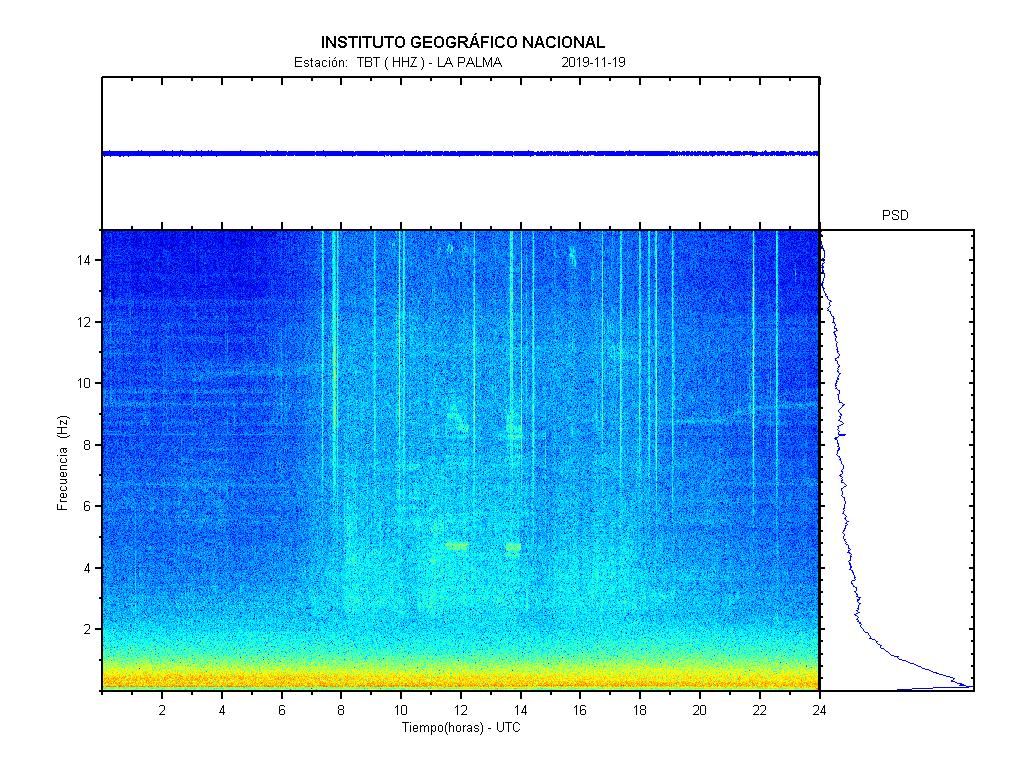
The graph for La Palma today.

2 users say Thank You to jand for this post
Reply Quote
At last and not before time.

Translated.

The EMU will test its response to an Earthquake and an eruption in the Canary Islands


"The Military Emergency Unit (UME) will carry out its great annual training exercise in 2020 in the Canary Islands, which mobilizes 3,000 to 4,000 troops from the three armies, to test what the response to an Earthquake in Gran Canaria would be, followed by an eruption in Tenerife

Each year, the EMU simulates a major emergency of national interest, in which this specialized unit would take over.

As announced on Monday by the head of this unit, Lieutenant General, Luis Manuel Martínez Meijide, in 2020 that great drill will take place in the Canary Islands from March 21 to 26.

In that exercise, he has detailed, such diverse aspects are taken into account as the impact of the natural disaster on goods of cultural interest or energy supplies, so that specialists from the Ministry of Culture or the large Spanish energy companies also participate in it .

Lieutenant General Martínez Meijide made this announcement during the visit that the acting Minister of Defense, Margarita Robles, has made to the headquarters of the UME in Torrejón de Ardoz (Madrid), where the bulk of the approximately 3,500 soldiers is concentrated of this unit of the Armed Forces that intervenes in case of catastrophes and natural disasters.

Around 1,400 UME troops will be available for the winter storm campaign, which has started prematurely with the first snowfall these days and that have already required their help to clear roads in the province of León.

According to the data offered, since 2007 the EMU has intervened in 33 cases related to winter storms (between 2 and 3 interventions per year), especially in León, Burgos and Castellón, in addition to 381 in forest fires and 53 in floods.

The last intervention, premature for the habitual thing, has been this same weekend, when 110 military equipped with 45 vehicles have cleared of snow roads of the Leonese municipality of Villablino and its districts that had affected 1,500 people, of which 200 remained No electricity for 24 hours.

During the storm campaign planned between December 1 and April 15, 2020, the EMU will deploy 1,400 soldiers, with 15 snow plows and a hundred vehicles prepared to act in adverse situations, to which this year a vehicle is added amphibious SUV.

The head of this unit, Lieutenant General Luis Manuel Martínez Meijide, has indicated that the EMU is now preparing for a possible new cold front of the northwest.

It will be, he said, softer than the previous one but the intention is to get ahead of him to avoid affecting the highways as happened on January 6, 2018, when 244 troops came to clean the AP-6 in what meant the most important of this unit related to winter storms.

The response time of the EMU, Meijide explained to journalists after offering the minister a summary of the campaign, is only an hour and a half to reach, for example, to towns in León, where the population is isolated and the job is also to "go house to house carrying medicine or fodder for cattle after a few days of isolation."

The minister has also highlighted the work of this unit, which is 14 years old and, according to Robles, "has shown that it is in difficult times with absolute preparation."


https://diariodeavisos.elespanol.com/201...d9YJnyFBsI
2 users say Thank You to jand for this post
Reply Quote
Interested read found and posted by Enrique regarding the eruption Tenerife 1909 if you click on the link at the bottom there are also photos to view.

Translated.

"Jorge A. Liria.- The eruption of the Chinyero volcano in Las Cañadas del Teide on November 18, 1909 revived the interest of the international scientific community for the volcanological phenomenon in the Canary Islands. The fact was reproduced by the press on November 20, being the first volcanic activity reproduced in a graphic medium within the history of the volcanology of the Canary Islands. The phenomenon aroused fears among people at first, although it did not cause personal injury and the materials were insignificant. This eruption, one of the three that met the twentieth century in our archipelago, was added to all those counted after the conquest, only for the case of Tenerife: Sietefuentes(December 31, 1704 - January 5, 1705), Fasnia (January 5-16, 1705), Arafo (February 2 - March 27, 1705), Garachico (May 5 - June 13, 1706), Chahorra or Nose of Teide ( June 9-September 15, 1798).
Crater activity had worsened in recent months. Numerous earthquakes that had been felt with constant constancy since June were enough data so that the eruption would not surprise the scientific community. The inhabitants of Tenerife already feared a few days before the start of the activity, proof of this is that days before this, up to 19 seismic movements of volcanic origin were counted in a single day.


Image of Chinyero erupting in 1909.
The eruption took place on a small mountain, about 40 meters, called on the Chinllara Mountain maps, and called by the natives of the area as Chiyero. This was an old horseshoe-shaped crater. The situation was about 15 meters above sea level and just over eleven kilometers in a straight line to Teide. That is why this eruption took place outside Las Cañadas. The Professor of the Faculty of Sciences of the Central University, Lucas Fernández Navarro, indicated in a lecture delivered at the Royal Spanish Society of Natural History on February 9, 1910: "(...) were therefore, of Las Cañadas, which constitute the depression in which the main crater sits. It is, therefore, an eccentric eruption, verified in one of the more or less sealed radiating indentations that, without a doubt, cross the Teide. "

The testimony of a pastor
The eruption of 1909 will be studied in this article from the point of view of social impact, for this we will first reproduce the contemporary testimony of an old pastor, José Hernández Lorenzo, who with his son was a few hundred meters from the place :

"It was half past two, and I was working on some treads and felt the earth shake under my feet. He once gave a hurry that I looked at the sky, thinking that I was passing through a large side of pigeons. I was already uneasy to look for the rope. to tie the woods and I felt another great hurry of the volcano as if it were coming down towards Teide. At the same time the ax began to ring alone against the threshing, that I saw myself again from what was coming from that. The earth was still trembling, and then they came some shepherds, and they all said: “we are going to leave that something bad has to come from this.” Soon my son arrived, and at that moment he burst the volcano.

Several locals approach the Chinyero during its eruption in 1909.
Where there was a volcano hole, in the same hill of the Chinyero mountain, it was where it burst. He took a great wound, and the brooms (bushes) jumped into the air, rising to a height like three large pines (70 or 80 meters), circling, scrambled with smoke and earth, black and red, large stones also came out, but there was no fire, and when it reached the top it was distended, and hot sandstones began to fall that could not hold in our hands.
We no longer saw each other because we all run away are returning the cab and throwing shoes to run better. We, without knowing where, went to the Fuente de la Vega (about six kilometers), without knowing where we were or what was happening to us. The burritos found them three days later on the Mountain of Flowers with the pinillo load covered with black sand, of which there would be three almudes. "

Within a few hours of what was described by these farmers, other mouths were opened to the Southeast, but this time it did not throw lavas, extinguishing at 24 hours, as well as the first, with a Northwest direction. The descriptions indicated that the open mouths had to be 9 in the first moments, arranged in a line of less than half a kilometer and in the Southeast - Northwest direction (towards Teide). Following the same descriptions, "the activity was concentrated very soon in the three central mouths, almost joined and still very well accused in the shape of the mountain."
These, the centrals, remained for several active days, until November 28. Vomiting lavas and producing frequent explosions with little intensity variations. Only a resurgence of it is collected on November 27, which the scientists of those years identified with the end of the activity prior to extinction. As of November 29 volcanic activity was reduced to the production of fumaroles: "(...) first bales, but large, and then more numerous and smaller."

Lasted ten days
A month later (December 24), from the direct observation made by Professor Lucas Fernández Navarro, it was obtained that at a certain distance from the cone, "the little plumes of gases of the fumaroles were already distinguished, and instead rising to it, you could see vapors flushing all over the outer surface. In the inner one, which had lost all the lapilli that covered it before, tiny explosions made the pebbles jump everywhere. "

Observers before the eruption of Chinyero in 1909.
The eruption finally lasted ten days, with a strombolian character, having been marked by the projection of very fragmented substances, not powdered, accompanied by scarce and dense vapors. On this, some photographs taken by the photographers of Tenerife, show a certain consistency that gases came to form in recent days. The photographic testimony becomes an important means of investigation on the phenomenon in the first moments.
It cannot be forgotten that the short duration of the latter prevented scientists from various states from being present. Being the only means of communication to reach the islands the ship. Acquiring photography a greater value, replacing the direct observation of phenomena.
It would be some photos that showed a stream of materials not vertical, but oblique towards the Southwest. The height reached by the tiny fragments passed according to the images, of 300 meters. Subsequent direct observation allowed to describe that the materials thrown were generally of great uniformity. "They all consist of a black matter, scoriaceous and for this light cause, although in reality of a lot of specific weight."
The descriptions made days later provide us with data of great importance, being the first volcanic phenomenon of emission of materials in the Canary Islands, attended by scientists. "There is not what in other volcanoes has been called ashes. The smaller fragments constitute a lapilli (zahorra they call it in the country), of very variable sizes. Of the larger fragments, which many measure more than one cubic meter, some they suffered a rotational movement in the air and constituted stromboilian bombs, without a different core. Others who have not experienced this movement, formed crushed masses of very rough and irregular surface, which when they fell made a hole in the layer of lapilli already deposited. "


The telegraph and the new communication
The Chinyero eruption, which occurred on the island of Tenerife in 1909, as we have highlighted, is the first photographed in the vulcanological history of the islands. And it is also the first on which field work is carried out with some seriousness. The first moments of the eruption on November 18 of that year, are curious, at least we will analyze what happened through the telegrams sent by the different authorities of the affected areas.

Once the eruption ended, many people approached the place.
Ignorance and fear had taken over the population of the northwest and south of the island. The first official telegraphic communication was sent by the Mayor of Icod to the Civil Governor of the province of the Canary Islands on the same day 18 at 11 in the morning:

"According to telephone reports received there are obvious signs volcanic eruption skirts south Teide in Las Cruces mountain. I just called mayor Guide by phone to confer. I will communicate VE all kinds of relative details tranquility neighborhood, Ruégole declare this telegraph office permanent."

The eruption could be seen from the sea, coming from La Palma to Tenerife. This was expressed by the passengers of the inter-island steam Viera and Clavijo . Days later thousands of people from Santa Cruz de Tenerife and La Laguna went to the heights of Tacoronte to observe the volcanological phenomenon. At the same time that this happened in the most remote areas, those closest to the event, such as Garachico, Icod, Santiago, Tank, Guía and Silos lived in the middle of panic.

The volcano seen from Las Canteras
Even the smoke from the volcano could be clearly seen on the morning of November 19 from the Port of La Luz and the Las Canteras beach, as reflected in its pages Diario de Las Palmas . Also from the Village of San Nicolás, Agaete or Gáldar you could see the columns emitted by the Chinyero.
While for others this represented a spectacle, for the inhabitants of the nearby areas the concern was enormous. The Commander of the post of the Civil Guard of Icod sent a telegram to the Civil Governor on the 18th at six minutes to six in the afternoon: "About 16 and 30 today they just brought the Mayor's own payment of the Vega to this one of the town of having seen smoke and feeling noise on 'Vencheque' mountains and the 'Botija' believing they are from seismic shocks. Town and fields very scary. "
The Governor's office received a huge number of telegrams in a few hours. Also the Mayor of Garachico sent another one, that same day. It was a quarter to seven when he indicated that the alarm was spreading in his town for "having exploited the mountain called 'Las Flores', throwing incandescent materials." The highest authority of the municipality indicated that he had issued orders for some men of the population went to find out where the lava ran.


More terror at night
A quarter of an hour earlier, the Mayor of Icod, sent a telegram back to the Governor. It reproduced in it the details given by the priest of the Santiago Valley: "Mountain chain South and in the so-called 'Chajorra', great detonations and smoke, obvious signs erupting, presenting this North direction. Forward how many cars are in that and Laguna. It would also be convenient for two ships in San Marcos port ".
The night seemed to increase the terror of the people, the strong lighting and the detonations characteristic of a volcanic eruption were the causes. It was then that again the Mayor of Icod sent another telegraphic office. I reiterated the request for help requested in the previous one. It indicated that the volcano was still increasing, feeling small seismic tremors. "(...) great detonations, reddish colored smoke column, illuminated by glare." The telegram already showed the first signs of real panic among the population: "People are already afraid: part of it move away from the road; another part is anxious to receive their help. Night infuses a great dread. Santiago Valley, the closest town to the catastrophe, has been abandoned. , fleeing neighborhood to the beach. VE can send you another ship. There are fears down lava between Silos and Garachico. Need to help the misfortune cases. "
The mobilization of ships is carried out promptly, and the next day the Guanche and Chana vapors entered the port of Santa Cruz de Tenerife loaded with people from the towns of southern Tenerife. At the same time, the León y Castillo steam , dedicated to inter-island mail, left the port along with several tugs carrying aid the same night. Even a warship of the Dutch navy departed from the Port of La Luz bound for Tenerife to provide its services in the event of a possible disaster. The vapors left the same night, drove a Red Cross ambulance, doctors and all kinds of aid. The Red Cross of La Laguna also left that night.

The Port of Santa Cruz crowded with people
On the 19th, the port of Santa Cruz de Tenerife was crowded with people. They waited for the arrival of the vapors coming from the towns of the south and north of the island. The first to arrive was the Sancho steam , chartered by three Garachico families. On the other hand, the terror had strange signs, such as the fact that many inhabitants of the small payments remained on the beaches, but without wanting to embark.
At five minutes to twelve on the 18th, the observed ones sent by the mayor of Garachico returned to the place of the eruption. They indicated to him, and thus he sent it to the highest provincial authority, that it did not threaten danger at the moment. The telegram seemed to calm down in the capital of Tenerife, but another received in the early morning of 19, about a quarter past four, by Captain Gerardo Gorrín from Guía de Isora, offered a very different vision:

"At 3 o'clock a new crater has opened between the Chiquerque Guide, having disappeared within five minutes, seen by a majority of neighbors, only salvation, sea. Régole send aid."

The Mayor of Icod remitted in those hours that the situation in Guía remained the same, and that his people at the moment were not in danger. The town located about nine kilometers saw the roofs of the houses filled with fine volcanic ash. Valle Santiago was totally depopulated, the same happened in the payments of Tamaimo and Arguayo. The closest to the volcanic eruption. Fear had reached El Tanque, whose population was alarmed. On this last town the Mayor of Garachico sent an alarming communication at four o'clock in the morning: "As I have just been informed by immediate residents of the Tank town, when this moment arrives, a phenomenon threatens to invade that term and can reach it. I will give details."
The agronomist Gordinez arrived in Garachico the afternoon of 19, aboard one of the rescue boats, the Veloz . He informed the Governor at 5 and 28 minutes: "(...) you cannot see whether or not there is immediate danger." He indicates that he was leaving immediately for Guía de Isora.

Leaving houses
3 kilometers long and 400 meters wide and average thickness over the land of 2 meters in 8 minutes: the other arm goes to the Ejos game, but is smaller and with less speed. The northern towns are guaranteed for today, as strong south wind increases stony, ash in the northern part of the mountain increasing thickness. "

Northwest of Tenerife, with volcanoes and nearby towns.
The people of El Tanque left their homes, marching to Garachico. The telegrams said: "(...) The most afraid to go outside fear misery for being poor." Andrés Arroyo communicated from Icod that the town was deserted, the peasants were lying on the roads. At the same time the mayor of the town, together with the deputy Padilla and other authorities of the Orotava and Puerto de La Cruz marched to a place near the crater.
The evacuation ended when on November 20 the Machrie steam arrived at the last minute with about 100 neighbors of the Silos, Garachico and Icod.
Ten days later the eruption ended without regretting personal injury, the materials were minimal. Everything had remained in an alarm that could have been avoided if a seismological and meteorological observatory had been installed in the Teide area, as several Spanish and foreign scientists had indicated years before."

https://complicesconlahistoria.blogspot....I_0jt_RsYg
3 users say Thank You to jand for this post
Reply Quote


Possibly Related Threads...
Thread Author Replies Views Last Post
  Canary Islands set for spectacular night sky display with four meteor showers Johnrgby 0 2,908 21-06-2025, 09:39 AM
Last Post: Johnrgby
  Majorero olive oil is once again the best in the Canary Islands TamaraEnLaPlaya 1 4,042 23-02-2024, 07:38 PM
Last Post: TamaraEnLaPlaya
  Volcanic activity in Canary Islands 2023 TamaraEnLaPlaya 80 34,206 20-12-2023, 07:30 PM
Last Post: TamaraEnLaPlaya
  The ban on limpets and burgados begins in the Canary Islands TamaraEnLaPlaya 0 3,150 01-12-2023, 08:48 PM
Last Post: TamaraEnLaPlaya
  Fuerteventura wants to be the breadbasket of the Canary Islands again TamaraEnLaPlaya 1 3,114 14-09-2023, 10:33 PM
Last Post: IHX

Forum Jump: